SAFE Flood Design Guidelines – Version 1.1
(Also known as “Englander 9-Box Matrix”)
Protected Under Creative Commons; Free Use permitted with Attribution
Location: Global Average
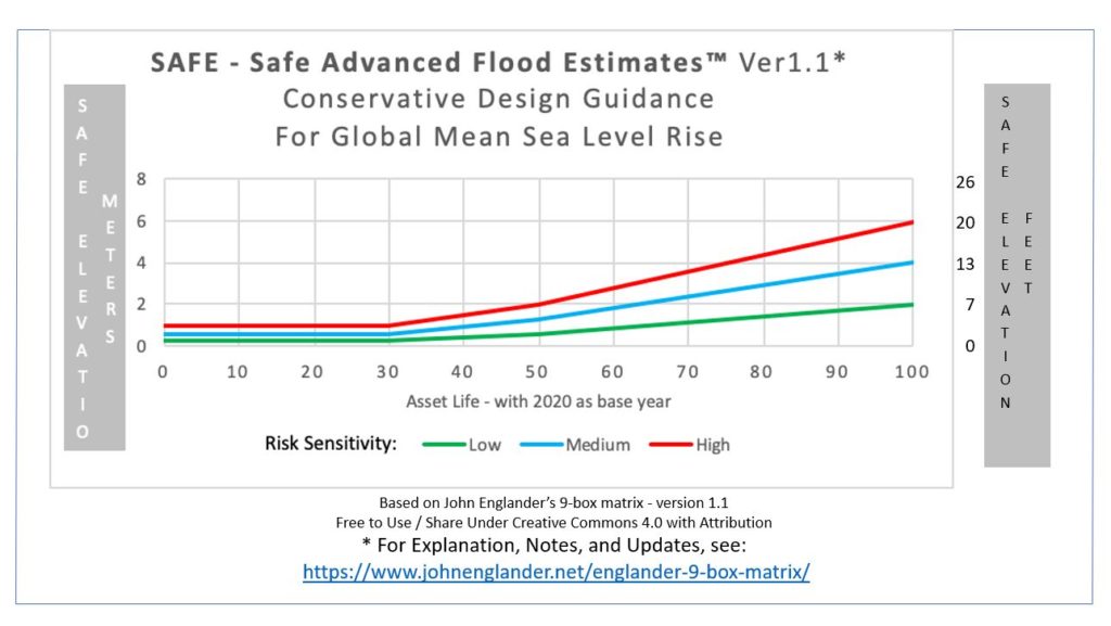
| Risk Sensitivity | 30 Years* | 50 Years | 100 Years |
| Low | 30 cm (1 ft) | 60 cm (2 ft) | 2 m (7 ft) |
| Medium | 60 cm (2 ft) | 1.3 m (4 ft) | 4 m (13 ft) |
| High | 1 m (3 ft) | 2 m (7 ft) | 6 m (20 ft) |
* Reference Year for projection = 2020, i.e. first column is approximately the
year 2050
Important Explanatory Notes:
- These estimates are for design and engineering guidance to allow for future sea level given the potential abrupt contributions from Antarctica and Greenland glaciers and are subject to change. For the latest updates, email us at info@risingseasinstitute.org and we will keep you up to date.
- Because of the uncertainty for the future rate of collapse of the “mega glaciers’ in the two major ice sheets and because these are intended to be safe estimates, they may be rounded upwards. The Metric and U.S. estimates are each done as “round numbers” and therefore are not exact equivalencies.
- These figures are based on the latest data, with proprietary interpretation by knowledgeable experts.
- These are global average values. In addition to these factors, locations should be evaluated for local land subsidence or uplift
- These factors for quasi permanent sea level rise are in addition to estimates for the usual short duration flood events from coastal storm surge, heavy rainfall, downhill runoff, and extreme tides.
- For calculation of drainage and water clearance heights, allowance should be made for the combination of higher base sea level plus, the extremes of rainfall and storms experienced in recent years and associated with the warming oceans – now at one degree Celsius, and predicted to be anywhere from two to four times higher this century, depending on the success to limit greenhouse gases.